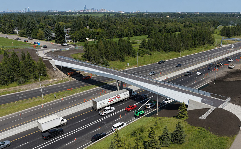
The new 142 Street Pedestrian bridge is now completed, providing a connection over Whitemud Drive at approximately 142 Street.
Project Update - The Bridge is Now Complete!
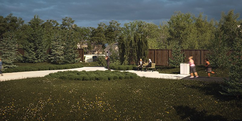
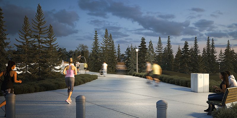
The 142 Street Pedestrian Bridge spans Whitemud Drive, connecting the Brookside and Brookview neighbourhoods to existing active transportation routes, including the shared pathway completed during Stage One of the Terwillegar Drive Expansion. The bridge and surrounding area include integrated lighting, bike racks and landscaping to support a safe and comfortable experience for all users.
About the Project
The Terwillegar Drive Expansion Program has identified a new pedestrian/cyclist bridge over Whitemud Drive, at 142 Street. The bridge will connect to the active transportation networks in Brookside and Brookview, including the newly constructed Stage One shared-use path. This project also includes amenities at either end of the bridge.
Whitemud Drive is a significant barrier to a planned district connector route identified in The Bike Plan and The City Plan. A new pedestrian/cyclist bridge will help resolve this barrier, enhancing access and connectivity for walking, cycling and rolling in southwest Edmonton and city-wide. Edmonton’s active transportation network is essential to achieving the outcomes of the City Plan and goals of ConnectEdmonton, Edmonton’s strategic plan.
Funding
The project is funded as part of the Terwillegar Drive Expansion Program and in partnership with the Government of Alberta. The City funding includes planning and design while detailed design and construction is funded by the Government of Alberta.
Frequently Asked Questions
How will this project impact community safety?
Public input is an important factor to this project, and we have heard how important community safety is through initial public engagement opportunities. The design of the bridge and open space amenities takes into account Crime Prevention Through Environmental Design (CPTED) principles. CPTED is a method to improve infrastructure safety ensuring the project design considers principles such as natural surveillance (“eyes on the street”) and encouraging positive activity.
What requirements are there to enclose the pedestrian bridge?
There are no policies or technical requirements for a pedestrian/cyclist bridge to be enclosed, for example, with a cage. To ensure the safety of all users, the design of the bridge uses railing heights and designs that discourage undesirable interactions between bridge users and Whitemud Drive.
A standard 1.4 m high railing has been included with minimal horizontal elements to discourage climbing activities. To mitigate objects falling onto Whitemud Drive below, the railing includes a continuous bottom plate and does not have large openings.
What is the width of the bridge and is there an opportunity for pedestrians and cyclists to be separated?
The bridge will have a clear width of 4.2 m, which is the standard for accommodating pedestrians and cyclists. Based on the anticipated ridership, it was determined that shared-use between pedestrians and cyclists would accommodate users safely and efficiently.
What anticipated impacts will new shared-use path options have on neighbouring properties?
The upgrades will be designed to minimize noise and light on adjacent properties. On this project, light impacts will be minimized through the use of modern lighting fixtures that are proven to nearly eliminate any light from the path onto nearby properties.
Can the bridge be directly aligned with 142 street?
Three bridge alignment options were considered and provided to the public for input. The options provided included one west of 142 Street and two east of 142 Street. From public input and technical information, the preferred bridge location was determined to be a hybrid of the options, slightly west of 142 Street.
Offsetting the alignment from 142 Street allows the design to avoid significant utilities which would potentially be costly to relocate.
Are active transportation connections on the north side of the bridge still planned?
During public engagement, three active transportation connections were shared: two shared-use path options running along the east side of Brookside, connecting the bridge to 53 Avenue, and the continued use of the existing shared roadway bike route on 142 Street.
The City is waiting until the bridge is built before implementing any active transportation upgrades on the north side of the bridge beyond connections to the existing network and the new Stage One shared-use path. This will allow us to gain a better understanding of how users and residents experience the bridge and to better inform improvements that could potentially be implemented in the future.
What will be the impact on existing trees and is this project considering planting additional trees in the area?
While tree removals are required, the project team has worked to minimize the number of impacted trees and to ensure construction activities do not compromise the integrity of retained trees. City-owned trees are a highly valued asset and are only removed when all other preservation options are unsuitable. The City will plant new trees and shrubs in the project area, including screening trees as well as flowering trees and shrubs, once construction is complete.
Are any additional open space upgrades being considered in the open space along the west and south/west sides of Brookside?
The open space is currently allocated as road right-of-way. While the City has received feedback indicating a desire to consider additional upgrades such as an off-leash dog park, playground space, exercise equipment, sitting space, washrooms and drinking fountains, the scope of the open space enhancement is limited to upgrades supporting the use of the bridge as a connection. The design of the open space amenities includes simple amenities such as a bench, waste container, signage, landscaping and lighting.
Is the existing toboggan hill impacted by this project?
No, the options maintain the existing toboggan hill as it is today.
Project Timeline

2027
2026
2025
2022/2023
2020 to 2022
Project and Public Engagement History
A comprehensive engagement process informed the planning and design of the bridge crossing. Through the engagement process, participants provided input to create a project vision and principles, identify opportunities, refine initial concept ideas, to inform the preliminary design. The design balanced public input, technical requirements and goals from City plans and policies.
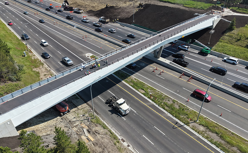
Construction continues on the 142 Street Pedestrian/Cyclist Bridge.
The new bridge will cross Whitemud Drive, linking the Brookside and Brookview neighbourhoods. This bridge will provide connections to existing and new active transportation paths, and provide a safe and reliable crossing across Whitemud Drive for those who walk, cycle and roll.
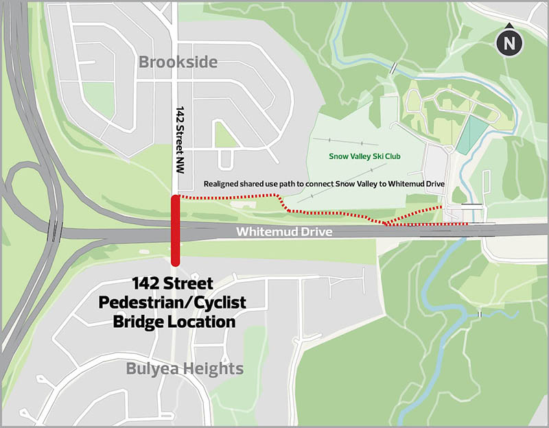
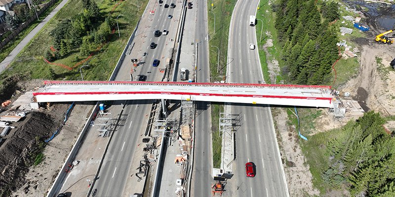
Early works on the construction of the new 142 Street Pedestrian/Cyclist Bridge have begun. The bridge will be built across Whitemud Drive at approximately 142 Street. It will connect the neighbourhoods of Brookside and Brookview to existing active transportation paths, including a newly built shared pathway that was completed in Stage One of the Terwillegar Drive Expansion project.
Construction is anticipated to be completed in late 2025.
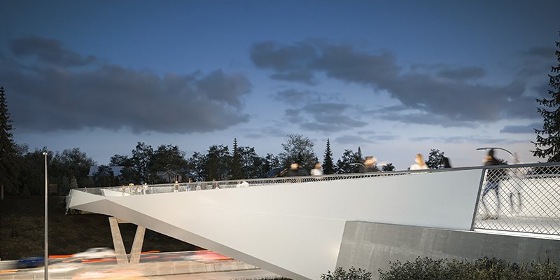
The new pedestrian bridge has been designed to include:
- Lighting integrated into the railing, improving user safety and experience
- A distinctive girder and railing design, ensuring an appealing, yet simple and functional design
- The addition of bike racks and posts (bollards) to prevent vehicle access at the north amenity zone
- Minor adjustments to the location, size and design of the amenity areas to ensure adequate space and separation for all users
Design of the footbridge is complete. The footbridge is expected to begin construction in spring 2024.
The last round of public engagement was completed in late 2021. Feedback shared by the public and interested groups has been reviewed along with the project vision and principles, technical requirements and policy factors. Based on this, the designs have been refined to include:
- A two-span bridge design option
- Lighting integrated into the railing, improving user safety and experience
- A distinctive girder and railing design, ensuring an appealing, yet simple and functional design
- The addition of bike racks and posts (bollards) to prevent vehicle access at the north amenity zone
- Minor adjustments to the location, size and design of the amenity areas to ensure adequate space and separation for all users
Thank you to everyone who participated in the online engagement activities for the fourth phase of engagement.
Learn more about the project by watching the preliminary design presentation.
As part of the public engagement process, we are committed to reporting back on how your input was collected and used. A report detailing the public engagement is presented in the What We Heard Report.
Thank you to everyone who participated in the online activities for the third phase of engagement. During this phase, participants were invited to provide input on the bridge design, active transportation connections and open space amenities. The preferred bridge location was also provided for information.
The public input activities included an online presentation and Question and Answer session on May 10, small group discussions on May 12 and online engagement was open from May 11-30, 2021. Your input will help refine the designs. The next public engagement opportunity will be held in late 2021.
Reference Materials:
Bridge Concept Design Options
Open Space Enhancements
Active Transportation Connections
Thank you to everyone who participated in the online public engagement activities from February 11 - March 5, 2021. Public engagement for this phase is now closed.
Reference Materials:
Option 1
Option 2
Option 3
Presentation Recording
The first round of public engagement was held between November 23, 2020 and December 13, 2020. During this phase, Edmontonians were engaged on what their priorities and values are for this project to directly inform the creation of a draft vision and guiding principles. The engagement also sought to gain a local understanding of the project context by asking residents about issues and opportunities they perceive in the study area.
Community Committee
To ensure a transparent public engagement process which creates opportunities for a diverse range of community members to contribute towards the decision making, the City formed a Community Committee. It was responsible for helping to adapt and adjust the public engagement process. The Community Committee was made up of neighbourhood residents, community organizations, and members of the public.
The Community Committee did not provide input on the design of the bridge or surrounding amenities/open space. The opportunity to share design related feedback was available through participation in the public engagement activities.